Back in January we visited the Nemo area in Morgan County where we rekindled our interest in bridges and tunnels. We perfectly timed our visit to the abandoned Nemo Tunnel #24 just when a train roared out of the active tunnel parallel to it. That experience whetted our interest in railroad tunnels, trestles and bridges. A little research online led us to some amazing trestles in East Tennessee. A sunny spring-like day in February provided the perfect opportunity to explore and trestle trek.
In a remote corner of Claiborne County we located the Lonesome Valley Bridge, a towering structure aptly named because it spans a deep valley at Daniels Gap.
The current metal structure replaced a timber trestle built in 1888-1889 but which tragically collapsed under the weight of a freight train June 14, 1892. The train plunged into the narrow valley killing the engineer, fireman and conductor. Two brakemen survived but suffered serious injuries.
Joie de Linda
Friday, February 26, 2021
Trains, Trestles and Tunnels Part 1
According to various reports, the train consisted of 2 or 3 engines and 14-17 cars, mostly coal cars, bound for Knoxville, TN from Middlesboro, KY. Train personnel had expressed misgivings about the structural integrity of the timber trestle and carefully approached the bridge at a reduced speed of about 20 miles per hour. However, the wooden bridge structure was not secure enough to bear the weight of the train. Upon reaching the edge of the trestle, the first engine hit the weakened segment, plunged downward pulling the other cars behind into the ravine.
Spanning 300 yards and reaching 140 feet from the valley floor, the "new" trestle bridge inspires awe. Imagine the view a train engineer would enjoy passing over this deep valley!
Imagine the faith it takes to cross this trestle!
Several times a week the Norfolk Southern Railway trains pass over this incredibly fragile-looking structure.
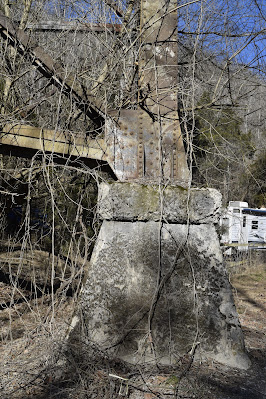
The footings show some erosion but remain secure.
A closer inspection shows the riveting.
Lonesome Valley Road, a gravel road in this area, passes beneath the giant trestle. Hidden in the vines beside the current footers are the old footers from the 1889 timber trestle.
It is difficult to capture the enormity of the structure.
I marvel at the ingenuity God has given man has to build such engineering feats.
Anchored on the north end, a section appears more recently painted.
Some of the locals have stories of their grandparents crossing the trestle as kids.
Standing farther back from the trestle, I still could not capture the entire structure in a photograph.
Because we got started after lunch, we knew that we would have to hustle to find our next destination, the Norfolk Southern bridge over the Powell River. Our trek would take us to Harrogate near Cumberland Gap where we would follow Gap Creek along a gravel road to the railroad bridge spanning the Powell River.
We came upon a section of the railroad spanning a small creek (Yellow Creek) and a gravel road (Marsee Spring Road). Even this trestle impressed us!
Directly across from the railroad trestle Gap Creek flowed under a rickety wooden bridge accessing a barn and field. Notice the road work where the shoulders and creek bank have been shored up and re-enforced. I imagine flooding is a frequent problem in some low-lying areas along the stream.
Upon closer inspection of the bridge, I'm not sure that I would have trusted it with any weight!
The gravel road leading away under the trestle invited us to explore another day.
I need to research the Gap Creek area. I have several questions. Is this Gap Creek the same creek which flows out of Gap Cave in Cumberland Gap? Does it travel underground for a portion of its trek? Was there once a mill situated at this small dam?
The picture below tells a story. Where the railroad lies well above the stream, the gravel road travels close to the stream and even partially fords the stream to allow vehicles to cross. Fortunately for us, we didn't have to cross the stream because a fork to the right allowed us to continue on downstream. Recent rains and snow melt caused washouts and erosion. The county workers were busy installing a culvert bridge to by-pass the stream ford.
We reached our destination! Except for two women enjoying a warm day with the temperatures near 70 degrees, Chris and I were the only people at the site. A local story is told of how children would walk across the bridge to go to school. One day a little girl followed by some neighbors crossed the trestle only to discover that a train was coming. Without enough time to outrun the train, the little girl dropped down as did the other children and held on as the train passed. All survived! I wonder if they told the story that day or waited until they were adults to relate the incident?
The design is a Warren deck truss bridge. Simply stated, a Warren Truss uses equilateral triangles to spread out the loads on the bridge.
Look closely to the left to see where Gap Creek empties into the Powell River.
This shot looks upstream a few yards from the stream's confluence with the Powell River.
On our return out of the valley, we had to wait while the construction guys secured their acetylene tank.
I am now hooked on researching and locating unique train trestles and metal bridges...and maybe a few abandoned tunnels. East Tennessee is rich in scenic beauty, unique structures and resourceful people.
Friday, February 12, 2021
Coker Creek
Where can we go that is not too far away, yet worthy of a hike on a rare sunny day in February? I know: a re-visit to Coker Creek! It has been nearly 10 years since we had visited the community and falls along the creek. Nestled in the shadow of the Unicoi Mountains, Coker Creek and Ironsburg communities offered a second look at their interesting history and natural beauty. Who knows...we might even find "some gold hidden in them thar hills!"
Placer gold was found along Coker Creek in 1831. Unlike the gold rush days out West, the gold in the Unicois was referred to as placer gold. Rather than a vein of gold running through rock which has to be extracted, placer gold is eroded by natural forces and "placed" or deposited in the streams.
Serious gold mining ended in this area by 1854 when the "prospectors" determined that panning for gold resulted in more effort than profit. I imagine that it would be fun to try panning for gold in the different area mountain streams.
What tales could be told if trails and roads could speak? The Unicoi Turnpike could speak of its beginnings as a trail to connect Cherokee towns in Tennessee, Georgia and North Carolina. Stretching from Vonore, TN to Murphy, NC, it was used by fur traders plying their wares in the 1700s. During the American Revolution colonists and the Cherokee used it to raid settlements. In the early 1800s enterprising folks turned it into a toll road or turnpike.
Below is pictured a curious implement... or modern art sculptor?
The turnpike later played a strategic role in the Civil War with both the Confederate and Union armies using it to transport soldiers, equipment and supplies.
Reminders of the brutality committed by deserters, known as bushwhackers, from both sides of the "not so civil" conflict lie buried in the Ironsburg Cemetery. One day I would like to wander through the cemetery reading the headstones of those who perished: the innocent members of the community as well as war veterans and bushwhackers. It must have been a fearful and dangerous time!
Turning off Highway 68, we enjoyed the drive to the Coker Creek trailhead along two forest service roads. Where once stood a sign at the intersection directing you to the falls, there is now only deep woods. The photo below is from 2012 when we visited Coker Creek with some hiking buddies. The sign is now missing.
Arriving at the parking area after a long gradual drop to the creek, we were pleasantly surprised to find we had the area all to ourselves. In fact, we encountered no one the entire time we were hiking or driving out of the national forest.
Usually we pack a picnic, but today we chose to stop in Tellico to grab some Subway sandwiches to go. Tailgating is the ideal way to picnic!
The stream at the parking area is deceptively docile. Just a short distance down the trail, the show begins! Rapids, single falls, partial falls, cascades and divided falls come one after the other!
The trail sign is a short way down the trail from the parking area. It begins level with the slow lazy stream.
It might be interesting to hike the length of the trail to the John Muir Trail where Coker Creek empties into the Hiwassee River. But a 2-car shuttle would be super inconvenient to arrange!
Just a short distance past the sign, we came to the first of many cascades and falls.

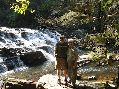
The big rock in the lower right corner of the picture is the same as the one our friends posed with 10 years ago.
Over the years, little had changed in the geology of the stream. The rhododendron has grown thicker in the intervening years.


The falls got more dramatic and impressive as we hiked downstream.
A spur trail takes the hiker closer to the stream for up-close views of the falls.
Standing between 2 mighty falls, the roar of the water reminded us of the Apostle John's description in the book of Revelation, "Then I heard something like the voice of a great multitude and like the sound of many waters and like the sound of mighty peals of thunder, saying, 'Hallelujah! For the Lord our God, the Almighty, reigns' " (Revelation 19:6).
At times, the waterfalls spread across wide jagged edges of rock.
Sometimes the rhododendron thickets blocked the view of cascades.
The spur trail joins the main trail and climbs high above the stream.
Sheer drops off the bluff prevent access to the stream below.
Although the stream is nearby and echoes through the valley, the forest is quiet and peaceful. Blow-downs are evidence of high winds, storms and ravages of pine beetle.
The trail begins a gentle descent until it reaches an accessible spot among flat weathered rocks.
The streams mighty flow squeezes between boulders as it tumbles further downstream.
A jumble of blowdowns required that we detour slightly.
We were curious about the strange blazes that marked the trail. Is this design unique to the Coker Creek Trail?
After exploring the flat area located about a mile past the parking area, we headed back.
I couldn't resist a couple more shots of some of the impressive waterfalls.
After days and days of cold, damp, gloomy weather, it was refreshing to be able to hike on a warm sunny day in February! Just look at that blue sky! The temperature nearly reached 70 degrees! Thank you, Lord, for the gift of sunshine and your beautiful creation!
What a glorious day we spent enjoying God's amazing creation!
Subscribe to:
Comments (Atom)


