With plenty of sunshine, warm fall temperatures and gorgeous fall colors beckoning us, we headed to middle Tennessee's Rock Island State Park to camp and explore.
The biggest features of the park are the waterfalls spilling part way down the bluff where the water from the lake behind the escarpment spills through the rock layers creating an amazing phenomenon. The entire bluff "weeps" giant waterfalls! The picture below was taken from an overlook on the opposite side of the falls.
The photo below was taken closer to the dam upstream.
The picture of the sandy beach was taken downstream from the falls but on the same side. The geology is fascinating. The beach is created naturally from the abundant sandstone weathered and deposited.
Another view of the Twin Falls is from near the Old Mill upstream but right below the dam.
The rocky features are obliterated by rushing water when the rainfall is so abundant the dam releases water.
Our campsite was small but easily accommodated our Casita camper and pickup truck with enough trees to allow us to use the hammock and even string a clothesline.
Dear friends, Linda and Maynard Nordmoe, joined us just a couple of sites beyond ours. They always bring an interesting assortment of games to play by lamplight.
Rock Island line is not a "mighty fine line" any more. Alas, it's heyday as a major crossroads has long passed, but the quaint train station has been repurposed into a craft gift shop. Look to the right of the historic marker to spot the old remains of the first transmission line, now replaced by huge modern transmission tower. The original line was built in 1913 by the Tennessee Power Company long before TVA. It extended 151 miles from Ocoee Dam #1 to Nashville.
Two rivers converge at Rock Island, the Collins River and the Caney Fork River. Our trailhead begins in the parking area near the historic marker.
We set out on a warm pleasant morning looking forward to a 3-mile trek through the woods.
Hmmm, the decision to cut short the hike....
Sometimes manways and unmarked trails lead to interesting spots. In this case, downhill off the trail we found a bench in a shady spot overlooking the lake.
It was a quiet spot.
The old truss bridge and the new highway bridge parallel across the Collins River, but you can see the Caney Fork just past the bridges.
Deep in the woods along the trail a bench invited us to sit a spell.
The dam backs up the Caney River just below where the Collins River merges with it. The Caney then passes through a deep gorge.
What surprised us on our loop hike was the myriad of giant trees scattered through the woods. Most were oak or poplar with branches bigger than mature trees. Yes, I am a tree hugger!
Although the trail was very evident, the blazes were not numerous. The joke at this spot was that the blaze was for a crawling hiker!
Another surprise awaited us 1/2 mile before trail's end: a cemetery with several Cunningham gravestones.
The oldest John Cunningham II, born just after the United States declared her independence, fought in the War of 1812.
Another relative, George Cunningham, served as a sergeant in Company D16 Tennessee Infantry with the Confederate States Army.
The cemetery clearing rested on a gentle rise in the woods surrounded by large trees.
Other family members' markers commemorate their lives.
It would be interesting to know if John Cunningham III was the son of John Cunningham II and perhaps died in the American Civil War.
Among the large trees was also a very large vine. I wonder if Jack climbed it to steal the goose that laid golden eggs.
Chris wants to measure this vine's circumference.
The trail meandered on the wide wooded area between the lake and the Caney River gorge with its Twin Falls.
We easily completed the pleasant 3-mile loop.
Rock Island was an important crossroads during the 1800s. Two major roads intersected. The Old Kentucky Road was a major North-South stage coach road which began in Maysville, Kentucky and linked to Huntsville, Alabama by way of McMinnville, TN and Nashville.
A portion of the old road is preserved.
Ironically, the Cunningham Cemetery is not the same cemetery where we spotted the 5-7 Cunningham graves in the woods.
The cemetery sits atop the Twin Falls which can easily be heard just over the edge of the escarpment 30 yards beyond the cemetery. It was strange to realize that all the water coursing through the rock layers was just several feet beneath us.
Down stream and yet still part of Rock Island State Park is a calm sandy area facing steep multi-layered bluffs.
Looking downstream the water gradually deepens as it flows into the lake created by the Center Hill Dam.
From the parking area overlooks, we saw a way to get down into the gorge upstream from the Twin Falls, but the hike down the bluff was not only steep but treacherous.
The gorge is very rugged with spectacular 70-90 foot waterfalls midstream.
The huge textile mill sits atop the bluff overlooking the gorge. Its history was short-lived but its economic impact was significant. Built in 1892, it provided jobs for more than 300 employees. It closed when its turbine was destroyed by the 1902 flood. However, many of the workers found employment when construction began in 1917 on the Tennessee Electric Power Company's dam and power house.
Today, the large mill sits boarded up and empty.
Old insulators cling to the side of the building.
The structure has changed little over the decades.
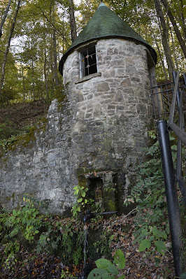
A quaint castle structure sits across the road from the old mill. It provided water for the community, mill and fire suppression. The spring still runs filling the walled reservoir in front.
Rapunzel, Rapunsel, let down your long golden tresses! Ha!
The spring pipe still flows faithfully.
A working pump and sink sit inside the springhouse.
Architecture for a cone-shaped roof must be quite challenging.
A single window looks out over the mill and gorge.
You can see the foundations of the old machine shop beside the mill. With all the working mill equipment, the machine shop was very important.
We never quite determined what this interesting rock formation represented, so we labeled it Stonehenge of Rock Island.
The Rock Island State Park sign welcomes the visitor just across the bridge spanning the Collins River Lake.
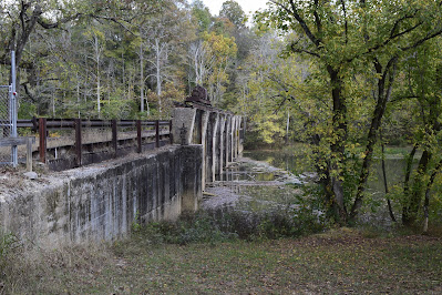
A "new" bridge replaces the old truss bridge.
The old sign's foundations are visible.
Amazingly, the old metal bridge was not torn down after the new bridge was opened.
Too bad the bridge cannot be repurposed into a pedestrian bridge or fishing pier.
Our third day camping was a perfect day to explore the area. We chose to revisit Burgess Falls, a 40-minute drive from our campground.
Appropriately named the Falling Water River, its spectacular water features, rock formations and a series of waterfalls increasing in size until you reach the huge Burgess Falls keeps the hiker anticipating.
Pictured are the remains of the suspension bridge supports and cables.
Looking closely you can see the remnants of a suspension bridge that supported a large flume that carried water from the dam upstream through a 100-yard tunnel downstream where another suspension bridge held a huge flume above the large falls bringing water to the powerhouse situated at the base of the great falls.
The falls above the great falls are impressive! With an elevation drop of 250 feet in less than a mile, the huge "smaller" falls are an amazing sight. Pictured is Middle Falls, at 80 feet the last cataract before the great falls.
With a plunge of 136 feet into the gorge below, the roar of the great falls fills the horseshoe shaped gorge.
Before the flood around 2013, the hiker could descend the gorge beside the falls via a metal stairway. Looking closely you can see the remaining bridge supports.
If you descend from the overlook down to the river's edge, you can see the top of the falls.
Upstream from the falls, flat rocks invite exploring.
During heavy rainfall, the flat rocks are covered with water.
Visitors looked for photo ops along the edge of the river.
Yep, what goes down must return up.
I think Burgess Falls is more spectacular than Fall Creek Falls.
The Middle Falls as viewed from beside the trail. The viewing platform was damaged by the 2013 flood and has not been rebuilt.
The dam was built in the 1920s to provide power to Cookeville but a massive flood in 1928 destroyed part of the dam and the powerhouse.
Remnants of the rail system used to open the floodgates sits rusting atop the dam.
Not a large dam by today's standards, the Burgess Falls Dam provided power to Cookeville until the mid 1940s when Cookeville switched to purchasing power from TVA.
Today the dam's spillways provide a pleasing water cascade for visitors.
After 4 days of perfect weather for hiking, relaxing and exploring, it was time to head back home.


