Where can we go that is not too far away, yet worthy of a hike on a rare sunny day in February? I know: a re-visit to Coker Creek! It has been nearly 10 years since we had visited the community and falls along the creek. Nestled in the shadow of the Unicoi Mountains, Coker Creek and Ironsburg communities offered a second look at their interesting history and natural beauty. Who knows...we might even find "some gold hidden in them thar hills!"

Placer gold was found along Coker Creek in 1831. Unlike the gold rush days out West, the gold in the Unicois was referred to as placer gold. Rather than a vein of gold running through rock which has to be extracted, placer gold is eroded by natural forces and "placed" or deposited in the streams.

Serious gold mining ended in this area by 1854 when the "prospectors" determined that panning for gold resulted in more effort than profit. I imagine that it would be fun to try panning for gold in the different area mountain streams.

What tales could be told if trails and roads could speak? The Unicoi Turnpike could speak of its beginnings as a trail to connect Cherokee towns in Tennessee, Georgia and North Carolina. Stretching from Vonore, TN to Murphy, NC, it was used by fur traders plying their wares in the 1700s. During the American Revolution colonists and the Cherokee used it to raid settlements. In the early 1800s enterprising folks turned it into a toll road or turnpike.

Below is pictured a curious implement... or modern art sculptor?

The turnpike later played a strategic role in the Civil War with both the Confederate and Union armies using it to transport soldiers, equipment and supplies.

Reminders of the brutality committed by deserters, known as bushwhackers, from both sides of the "not so civil" conflict lie buried in the Ironsburg Cemetery. One day I would like to wander through the cemetery reading the headstones of those who perished: the innocent members of the community as well as war veterans and bushwhackers. It must have been a fearful and dangerous time!

Turning off Highway 68, we enjoyed the drive to the Coker Creek trailhead along two forest service roads. Where once stood a sign at the intersection directing you to the falls, there is now only deep woods. The photo below is from 2012 when we visited Coker Creek with some hiking buddies. The sign is now missing.

Arriving at the parking area after a long gradual drop to the creek, we were pleasantly surprised to find we had the area all to ourselves. In fact, we encountered no one the entire time we were hiking or driving out of the national forest.


Usually we pack a picnic, but today we chose to stop in Tellico to grab some Subway sandwiches to go. Tailgating is the ideal way to picnic!
The stream at the parking area is deceptively docile. Just a short distance down the trail, the show begins! Rapids, single falls, partial falls, cascades and divided falls come one after the other!

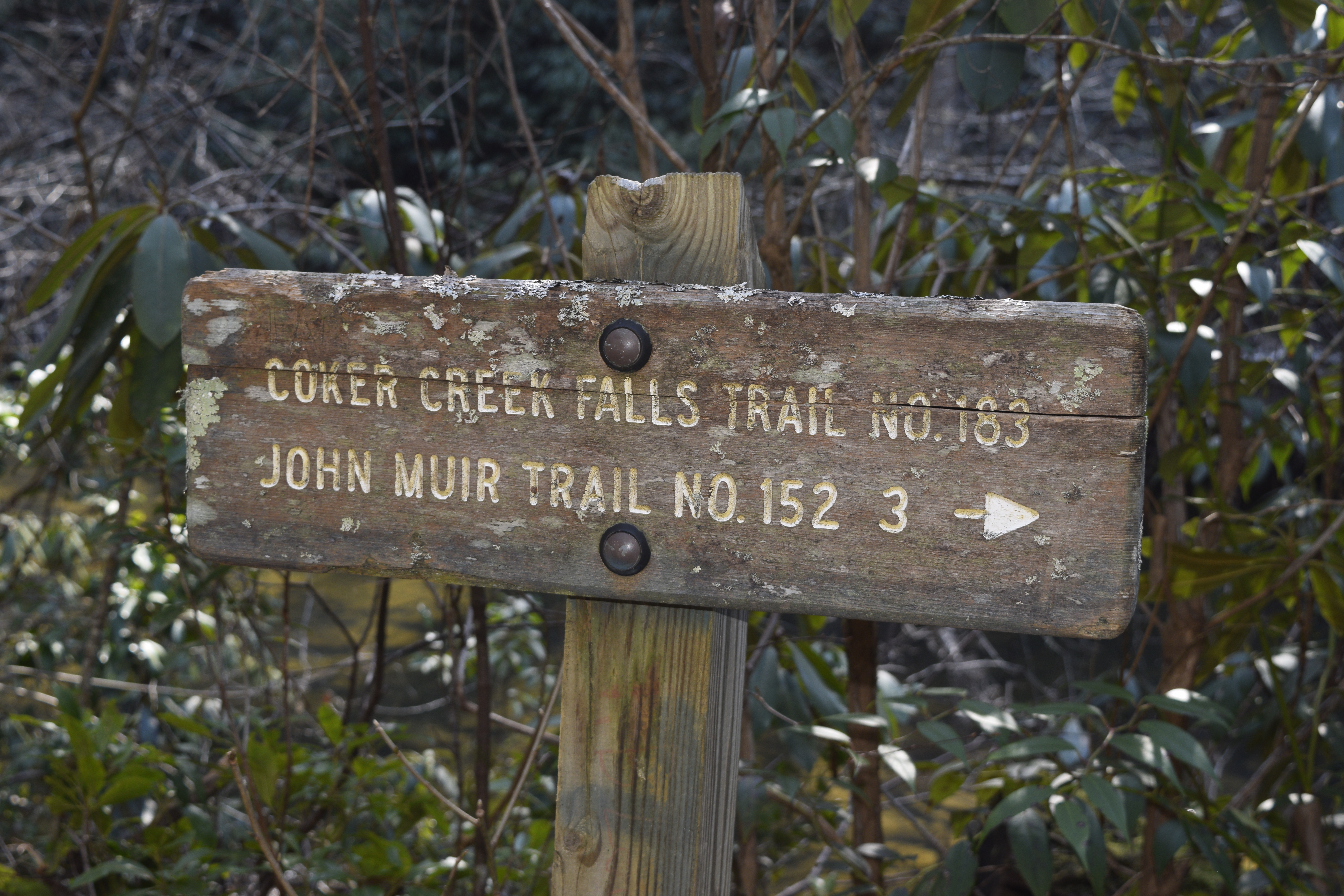
The trail sign is a short way down the trail from the parking area. It begins level with the slow lazy stream.

It might be interesting to hike the length of the trail to the John Muir Trail where Coker Creek empties into the Hiwassee River. But a 2-car shuttle would be super inconvenient to arrange!
Just a short distance past the sign, we came to the first of many cascades and falls.


The big rock in the lower right corner of the picture is the same as the one our friends posed with 10 years ago.

Over the years, little had changed in the geology of the stream. The rhododendron has grown thicker in the intervening years.


The falls got more dramatic and impressive as we hiked downstream.

A spur trail takes the hiker closer to the stream for up-close views of the falls.

Standing between 2 mighty falls, the roar of the water reminded us of the Apostle John's description in the book of Revelation, "Then I heard something like the voice of a great multitude and like the sound of many waters and like the sound of mighty peals of thunder, saying, 'Hallelujah! For the Lord our God, the Almighty, reigns' " (Revelation 19:6).

At times, the waterfalls spread across wide jagged edges of rock.

Sometimes the rhododendron thickets blocked the view of cascades.


The spur trail joins the main trail and climbs high above the stream.

Sheer drops off the bluff prevent access to the stream below.


Although the stream is nearby and echoes through the valley, the forest is quiet and peaceful. Blow-downs are evidence of high winds, storms and ravages of pine beetle.

The trail begins a gentle descent until it reaches an accessible spot among flat weathered rocks.

The streams mighty flow squeezes between boulders as it tumbles further downstream.

A jumble of blowdowns required that we detour slightly.


We were curious about the strange blazes that marked the trail. Is this design unique to the Coker Creek Trail?

After exploring the flat area located about a mile past the parking area, we headed back.

I couldn't resist a couple more shots of some of the impressive waterfalls.

After days and days of cold, damp, gloomy weather, it was refreshing to be able to hike on a warm sunny day in February! Just look at that blue sky! The temperature nearly reached 70 degrees! Thank you, Lord, for the gift of sunshine and your beautiful creation!


What a glorious day we spent enjoying God's amazing creation!
To think that what used to be farmed and panned and traveled and fought over and hunted now "we were pleasantly surprised to find we had the area all to ourselves". Will the youth scour the forests to see God's beauty and drink in the solitude, or is it just another trail run to be conquerered or test space for outdoor equipment? Thank you for your God honoring, historically contexted commentary on a little walk in the woods.
ReplyDelete